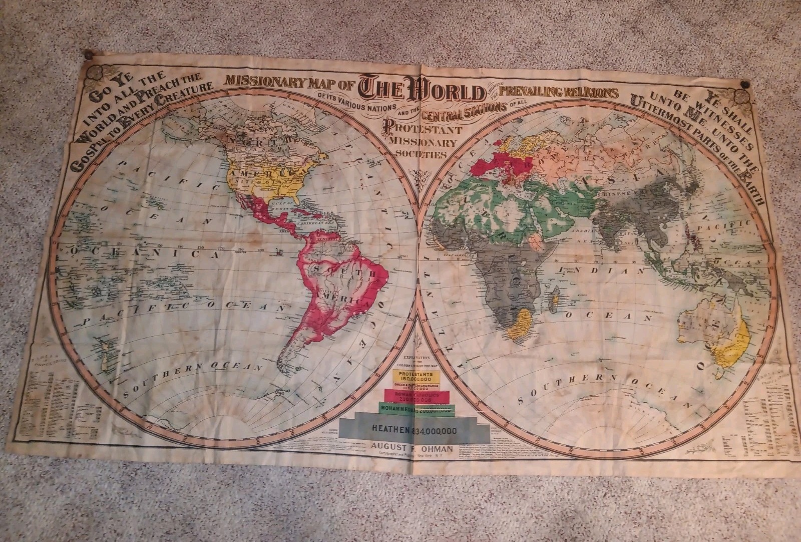
Missionary Map of the World Protestant Missionary Societies August Ohman Cloth

When you click on links to various merchants on this site and make a purchase, this can result in this site earning a commission. Affiliate programs and affiliations include, but are not limited to, the eBay Partner Network.

Missionary Map of the World Protestant Missionary Societies August Ohman Cloth:
$9500.00
82" x 46 1/2" Please look at all photos to see the condition. There is some staining throughout and in the center where it is sewn together there is some tears and holes. Overall the colors are very nice and would display very well.
This enormous banner features a double-hemisphere map of the world, with national boundaries delineated by dashed lines and major cities identified. Areas served by Protestant missions are underlined in green for American missions and red for foreign missions. Each space between the parallels is assigned a unique letter along the borders, and the spaces between meridians are numbered along the equator. This yields an alphanumeric code for each location, enabling the viewer to find any particular mission by means of an index in A Manual to Accompany Colton’s Missionary Map of the World (A facsimile reprint of the Manual will be provided with the map.) The upper corners bear an exhortation to “go ye into all the world and preach the gospel to every creature,” while the lower border features tables of population by continent. The banner’s great size, color scheme, decorative lettering, and foliate ornamentation all combine to render this a most impressive and attractive production.From the Manual we learn that Joseph Hutchins Colton had produced a similarly massive missionary map some 30 years previously (likely 1846), but that the plates were destroyed. In response to demand from missionary societies and religious educators his sons Charles and George set out to produce a new, updated map. To that end they combed through reports of dozens of major and minor missionary societies, both American and foreign, with the result being “the most complete map of the kind ever made, both in appearance and in the extent and accuracy of its information.” (Manual, pp. 3-4)An article in the Missionary Herald indicates that the 1846 map–and by inference the new version offered here—were intended “for monthly concerts, Sabbath schools, lectures on missions, and even for the instruction of common schools in geography, it will be found an important auxiliary.” (Missionary Herald, vol. XLI no. 12 (December, 1845), p. 418) Hence the map’s great size, which made it well suited for display before large groups, and the use of linen, which rendered it both durable and portable. A September 1846 report of the American Board of Commissioners for Foreign Missions testifies to the usefulness of the format:“The extensive use of these maps in lectures on missions and at the monthly concert of prayer, is doing much to diffuse definite information as to the condition and wants of the unevangelized world and the progress of evangelical missions, and to promote effort and prayer for the universal promulgation of the gospel.” (p. 83)In addition to the J.H. Colton map of 1846 and the G.W. and C.B. Colton map of 1878 offered here, in 1892 the Coltons published another mammoth map, being the Missionary Map of the World showing the Prevailing Religions of its Various Nations and the Central Stations of the Protestant Missionary Societies. This appears to be more or less the same size as our map and may be from the same plates, though the title and borders have been completely altered, and color is used to indicate the predominant faith of each region. After the Coltons were bought out by August R. Ohman in 1893, the latter issued a map of the same title but much smaller format in or around 1906 (OCLC 978265157), followed by a Missionary Map of the World showing the Prevailing Religions of its Various Nations and the Central Stations of the Seventh-Day Adventists (OCLC 233036366).All versions appear to be extremely rare. OCLC describes only the two Ohman editions, each with a single institutional holding, while the Library of Congress holds the 1878 map. Of all the editions, I find record of only three examples having appeared on the antiquarian market: examples of the 1892 map sold in 2001 by Old World sales and in early 2017 by Altea Gallery, and an example of the ca. 1906 Ohman map sold by Altea in 2016.
(As taken from Boston Rare Maps web page)
Missionary Map of the World Protestant Missionary Societies August Ohman Cloth:
$9500.00
Related Items:
Missionary Map of the World Protestant Missionary Societies August Ohman Cloth
$9500.00
1861 1863 Missionary Reports Maps China Hawaii Armenia ABCFM Antique Lot
$250.00
1850 antique MISSIONARY MAP ROOM CIRCULAR letter envelope PAYMENT DUE bidwell
$124.95