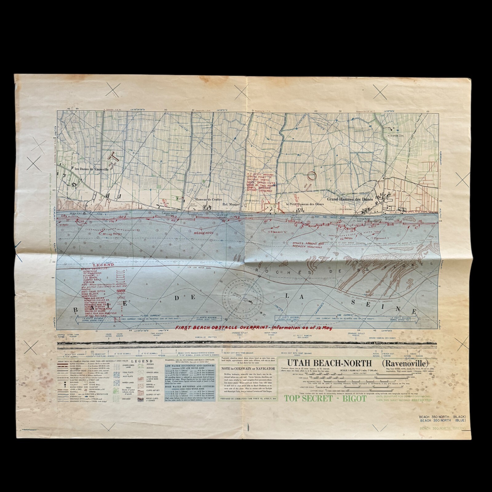
VERY RARE WWII 1944 TOP SECRET D-Day Lt. Price LCT-2454 Utah Beach BIGOT Map

When you click on links to various merchants on this site and make a purchase, this can result in this site earning a commission. Affiliate programs and affiliations include, but are not limited to, the eBay Partner Network.

VERY RARE WWII 1944 TOP SECRET D-Day Lt. Price LCT-2454 Utah Beach BIGOT Map:
$23550.00
Comes with hand-signed C.O.A.
Size: 20 × 25 inches
Titled UTAH BEACH-NORTH (Ravenoville) this exceptionally rare, museum-grade TOP-SECRET BIGOT D-Day invasion map is an extraordinary D-Day artifact from one of World War II’s most pivotal moments. This heavily-used D-Day beachhead invasion map, integral to the success of Operation Overlord, belonged to Lieutenant John L. Price, the Commanding Officer of Landing Craft Tank (Assault) LCT (A)-2454. Lieutenant Price and his crew played a crucial role in the D-Day landings at Utah Beach.
On June 6, 1944, at 7:10 AM, LCT (A)-2454 landed on Utah Beach as part of the third assault wave arriving just 15 minutes after the initial landings. Under relentless fire from German defenses, Lt. Price’s crew successfully unloaded some of the first Sherman tanks from Company C, 70th Tank Battalion, along with an engineer bulldozer. This specialized bulldozer was tasked with breaching the heavily fortified sea wall, a critical obstacle preventing the advance of Allied forces. The tanks and bulldozer quickly set to work, dismantling beach defenses and paving the way for further waves of troops and equipment on Utah Beach.
Adding to the complexity of their mission, LCT (A)-2454 towed LCPL (Landing Craft Personnel Large) smoke generators designed to obscure Allied movements and shield landing craft from German visibility. However, towing these smoke generators significantly reduced the vessel’s speed and maneuverability, delaying their arrival at the beach. Despite this challenge, Lt. Price and his crew executed their mission with precision, delivering their vital cargo of Sherman tanks and the bulldozer to the battlefield. The landing craft sustained damage during the assault but managed to retract from the beach and return to the transport area with only minimal injuries among the crew—a testament to their resilience and skill under fire.
The stakes of this mission were immense, and the costs were significant. Across the Normandy invasion, 16 Landing Craft Tanks (LCTs) were lost, including two at Utah Beach. Personnel casualties at Omaha and Utah Beaches totaled 4 KIA, 5 MIA, and 28 wounded. These figures underscore the sacrifices made by Allied forces during this monumental effort to establish a foothold in enemy-occupied France and begin the liberation of Europe.
This map vividly illustrates the extraordinary level of planning and operational detail that went into Operation Neptune, the seaborne component of the D-Day invasion. Prepared by Commander Task Force 122 on April 21, 1944, this double-sided BIGOT map was one of the most critical resources used during the landings. Its designation as the“FIRST BEACH OBSTACLE OVERPRINT - INFORMATION AS OF 12 MAY” makes it particularly significant. This version was part of the first and most detailed series of BIGOT maps, offering an unprecedented view of German Atlantic Wall defenses, enemy fortifications, and critical beach obstacles along Utah Beach. Such intelligence was essential for navigating the fortified coastline and countering enemy resistance with precision and effectiveness.
This remarkable artifact preserves the story of Lieutenant Price and the men of LCT (A)-2454, whose courage and determination were vital to the success of the D-Day landings. It stands as a tangible connection to the bravery, strategy, and sacrifices that defined this historic operation.
DETAILED INFORMATION ABOUT THE CREATION OF THIS 1944 WWII D-DAY BIGOT MAP:
The BIGOT map is an extremely detailed topographical map, with roads and built-up areas in black, green indicating different types of vegetation; and brown indicating elevations and topographical features, including the steep bluffs overlooking the beach. A variety of dashed lines in the water indicate depths at low (brown) and high (blue) tides.
Below each map is a profile view of the coastline to facilitate navigation by the landing craft, with the practical note “Building landmarks, especially near the beach, may be destroyed before any craft land. Terrain features, therefore, are much more reliable for visual navigation.”These photos would have been taken from midget submarines with a crew of two, and sometimes four men, at great risk to their lives. These British sailors were among the relatively unknown heroes of D-day.
Below the title brief note hints at the complex, multi-layered information-gathering effort that yielded the BIGOT maps. The BIGOT maps were the product of a multilayered TOP SECRET effort: Starting with existing base maps and hydrographic data, largely supplied by the British Hydrographic Office, military cartographers and artists added data from aerial reconnaissance surveys by Allied warplanes, including extraordinarily dangerous low-level overflights. To these were added information from a host of other sources, including reconnaissance of the beaches by commandos (“frogmen”) and reports from French Resistance fighters.
The reverse side of each BIGOT map had detailed hourly currents, beach gradients, and tidal stages.
“BIGOT” CLASSIFICATION:
“Top Secret – Bigot” was the Allies’ highest level of secrecy during WWII. The Bigot List was a list of a very exclusive group of named individuals who were the only persons allowed to know both the proposed sites and dates of the D-Day Landings. Because of the danger of capture by the Germans the only person on the Bigot List allowed to go outside mainland Britain is believed to be Winston Churchill and as a safeguard his personal bodyguard was instructed to shoot the Prime Minister if there was any danger of him falling into enemy hands.BIGOT was a World War II security classification at the highest level of security - above Top Secret.; BIGOT stood for the British Invasion of German Occupied Territory, was chosen by Churchill before America came into the War and remained the security classification even when Eisenhower took over the planning role.
In “Untold Stories of D-Day” in the June 2002 issue ofNational Geographic Magazine, Thomas B. Allen wrote about the Neptune Bigot maps: “One simple word, BIGOT, is stamped in big letters across the Operation Neptune Initial Joint Plan of February 12, 1944, and from then until June 6, that stamp appeared on all supremely secret pieces of paper handled by D-Day planners. If any of those papers or maps had fallen into enemy hands, the invasion would have failed or been scuttled… BIGOT was a code word within a code word, a security classification beyond Top Secret. When planners adopted Neptune as the code word for the naval and amphibious aspects of the invasion, they realized that greater protection had to be given to any document or map that even hinted at the time and place of D-Day. They chose the odd code word BIGOT by reversing the letters of two words—To Gib—that had been stamped on the papers of officers going to Gibraltar for the invasion of North Africa in November 1942. Those who were to get date-and-place information were given special security background checks. If they qualified, they were described as ‘Bigoted…
The BIGOT maps and documents were created in isolated cocoons of secrecy. One was hidden in Selfridges department store in London. BIGOT workers entered and left Selfridges by the back door, many of them knowing only that they were delivering scraps of information that somehow contributed to the war effort. Others with BIGOT clearances worked on Allied staffs scattered around London and southern England. So restricted was the BIGOT project that when King George visited a command ship and asked what was beyond a curtained compartment, he was politely turned away because, as a sentinel officer later said, ‘Nobody told me he was a Bigot.’
But nothing was more secret—or more vital to Operation Neptune—than the mosaic of Allied intelligence reports that cartographers and artists transformed into the multihued and multilayered BIGOT maps. On them were portrayed details of Hitler’s vaunted Atlantic Wall, a network of coastal defenses, designed to repel invaders. To discover what the Allied invaders faced, American, British, and French operatives risked their lives—and sometimes gave their lives—in the process of filling in the BIGOT maps. Revelations about Normandy’s undulating seafloor came from frogmen who also got sand samples on beaches patrolled by German sentries. Such BIGOT map notations as ‘antitank ditch around strongpoint’ or ‘hedgehogs 30 to 35 feet (9 to 10 meters) apart’ were often the gifts of French patriots.” Notations in red on the map here offered to include: “Probably Mined” and three areas marked “Drainage Ditch.” Allen writes that “French laborers conscripted by the Germans paced distances between obstacles or kept track of German troop movements… BIGOT maps began with information gleaned from old scenic postcards of the Normandy coast and charts from the Napoleonic era. Next came the special deliveries from the French Resistance. Then in mid-May 1944, BIGOT mapmakers asked for low-level aerial photos of the coast. Pilots trained to fly at 10,000 feet, called this wave-top flying ‘diving’ because they felt that in their unarmed and unarmored aircraft they were rolling the dice with death.
D-Day and Utah Beach:
Airborne landings begin 0015
H-Hour, beach landings 0630
Lead Allied assault forces:
Airborne landings: 82nd & 101st US Airborne Divisions
Beach landings: 4th US Infantry Division
German defenders:
Troops from 709th Infantry Division, 91st Airlanding Division and 6th Parachute Regiment
Objectives:
Only four causeways lead away from the beach through an area that has been flooded by the German defenders. The US Airborne forces land early in the morning to take control of the inland ends of these causeways, as well as other key roads and bridges. They then have to hold these objectives until troops from the beach landings can reach them.
VERY RARE WWII 1944 TOP SECRET D-Day Lt. Price LCT-2454 Utah Beach BIGOT Map:
$23550.00
Related Items:

PSA 10 Breadbug Pikmin 2 E-Card No. 060. ONE OF A KIND. VERY SPECIAL. MEGA RARE.
$4200000.01
$1000000.00

Very Rare Albino White M&M Candy
$750000.00